Hi there,
Today I am going to tell you about the places we visited during our stay in Quito.
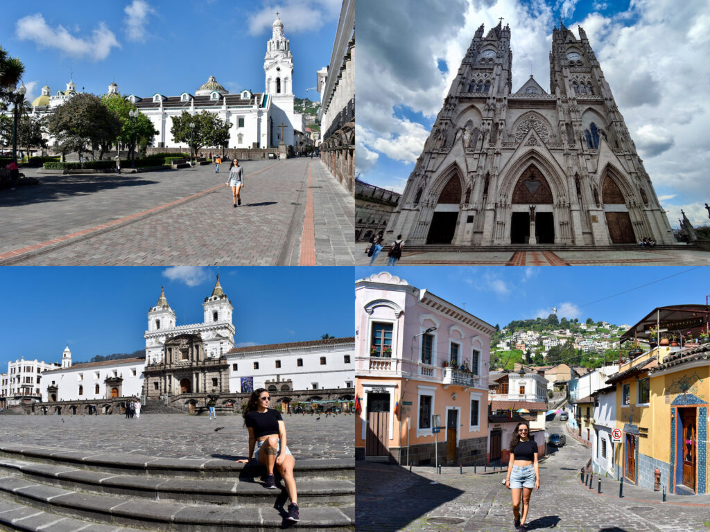
City Center
The center of Quito is the best-preserved historical complex and one of the most important in Latin America. It was named Cultural Heritage of Humanity by UNESCO in 1978.
From our accommodation we walked, and it took us 45 minutes.
We liked it a lot as it is very well preserved and clean. If I compare, the center of Lima was more modern, and Quito is more colonial. It is better to go early because after noon, it gets crowded.
In the center you find many street vendors and you get things cheaper than in the supermarket. We bought a bag of fried beans for $1, 3 pineapples for $5 and the coconut for $1.50.
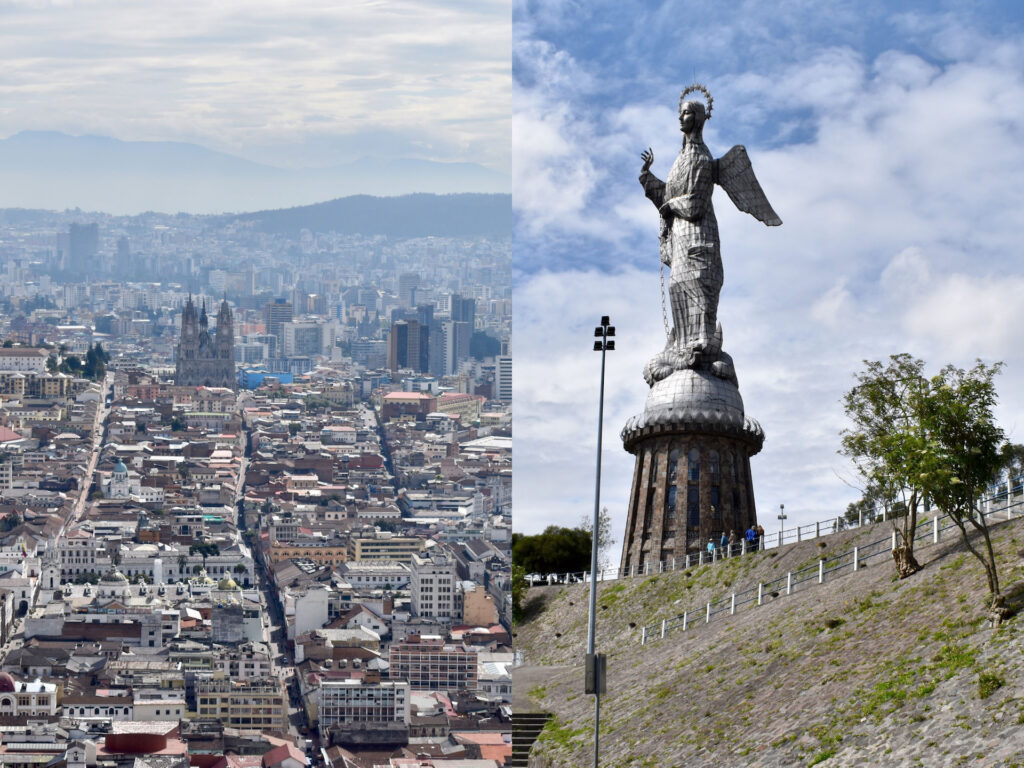
Panecillo
We got to the Panecillo by taxi because we had gotten up late that day. Although it is the most visited place in the city, there is nothing to do but the photo of the Panecillo and the views of the city.
We walked down towards the center through a neighbourhood of humble houses and shacks that did not look dangerous (and less if I compare with everything we saw in Colombia). In a square we grabbed a taxi that was passing by because the Uber took a long time, and we went back to the house.
On one of the excursions we did with our friend Edward, he told us that we had to go up and down with the same taxi. When we told him that we had walked down, he was horrified because that area was extremely dangerous. A taxi driver also told us that there was a gang there that was constantly robbing.
Maybe we saved ourselves from being robbed by going early or it was our lucky day.
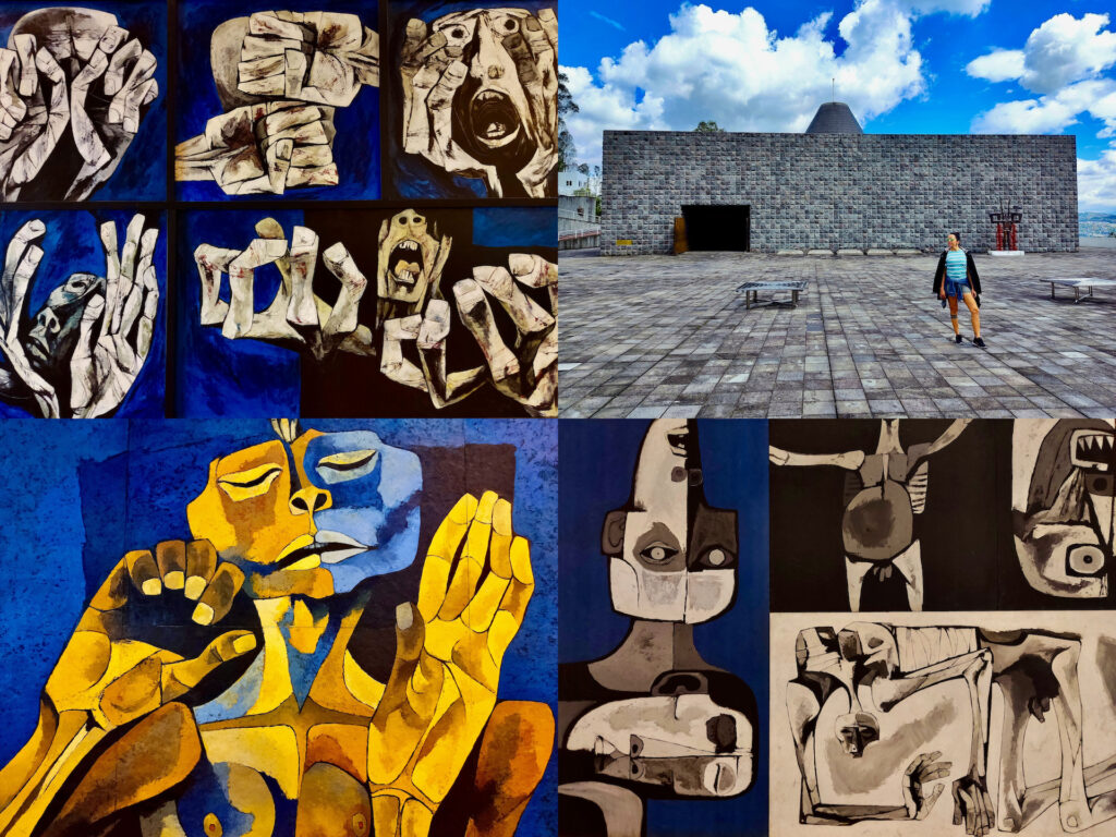
Museums
We went to these museums:
- City Museum – $5
- The Chapel of Man and Guayasamín House Museum – $10
- Museum of Pre-Columbian Art – $5
We visited few museums because we gave priority to hiking and because coming from Peru, it was repetitive for us to see pre-Columbian art again.
I thought I had visited the Guayasamín museum, but the memory I had was from a souvenir shop. The entrance is expensive, but I think it’s worth it. In the Chapel of Man are the greatest works of his last stage and in the house, you have the pieces of his beginnings.
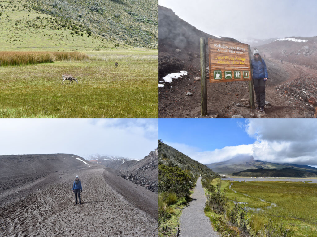
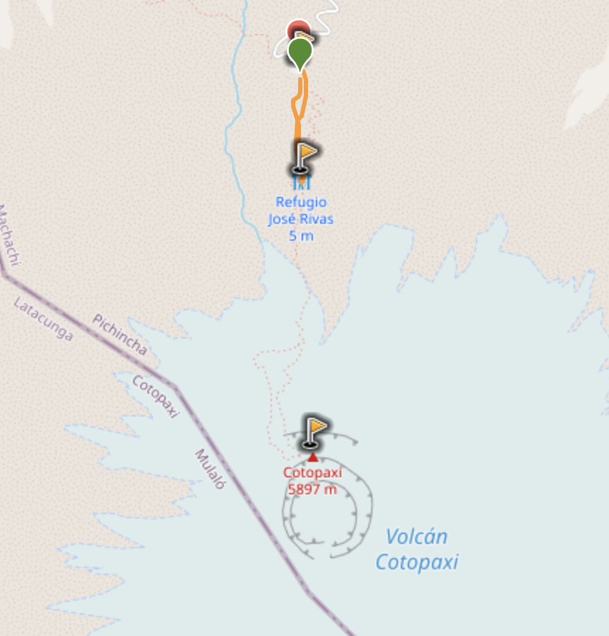
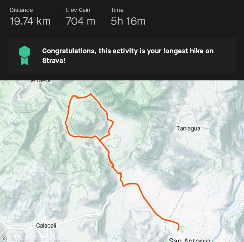
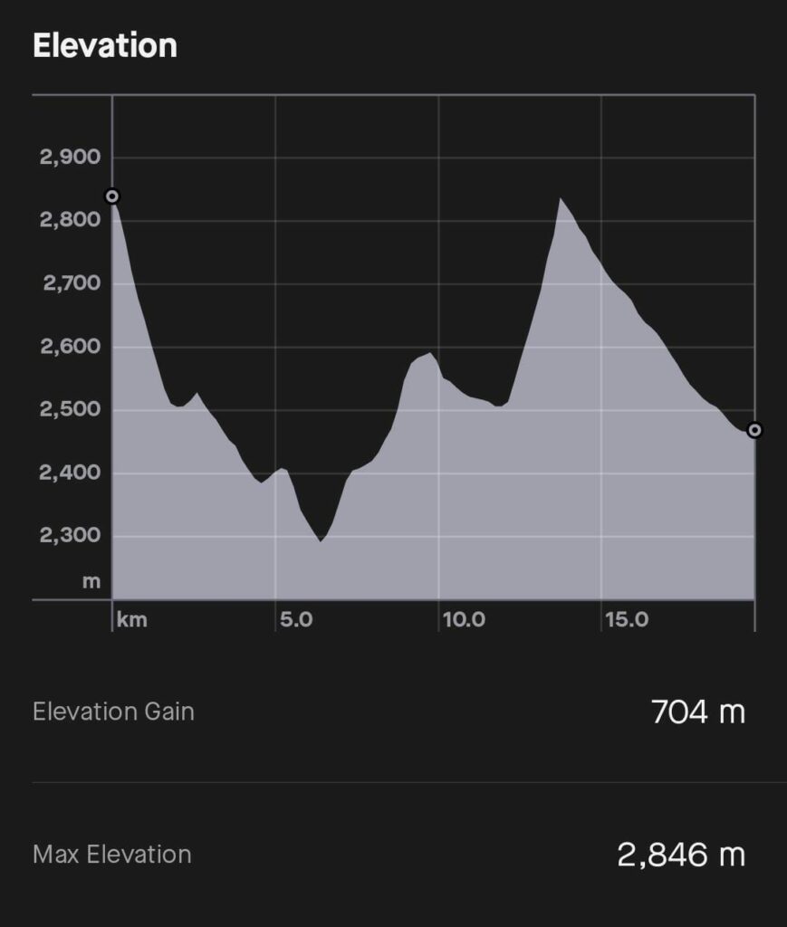
Cotopaxi volcano
This was our first excursion. The hostess of our accommodation had put us in contact with a guy who we had not yet met in person since a friend of his was the one who had picked us up at the airport.
Edward picked us up at 6AM and we started our way to Cotopaxi.
There is no entrance fee because a few years ago they eliminated the charge to access the National Parks. At the entrance of the reserve, if they see that you are a foreigner, they force you to hire a park guide who can charge you around $40. Edward said we were locals, so we got through with no problem.
In Quito we were at 2850 m, and it was already difficult to climb a few steps. The José Ribas refuge is at 4810 m, and I felt that it cost me my life to get there (only 1.7km round trip). In addition, as soon as we started the route, it got terribly windy with rain and sleet. I covered my face with the scarf because of the pain of the cold.
Edward told us that the groups had not been able to reach the summit that day due to weather conditions. People arrive at the refuge, and it is at night when they start their way to the summit because that is when the weather is better.
I was amazed because Edward told us that we hiked very well and that he could tell that we were in good physical condition; that with a little more training, we could climb to the summit of Cotopaxi. I was surprised to hear that because I felt like the slowest person in the world at that moment.
Then we visited the Limpiopungo Lagoon and saw deer.
That day we fell in love with Edward because he was so much fun and had the most entertaining stories imaginable. The return was 3 hours by car, and time flew by. Also, as soon as he saw how I scolded Diego, he started calling me “Monster” and that was my nickname for the rest of the excursions.
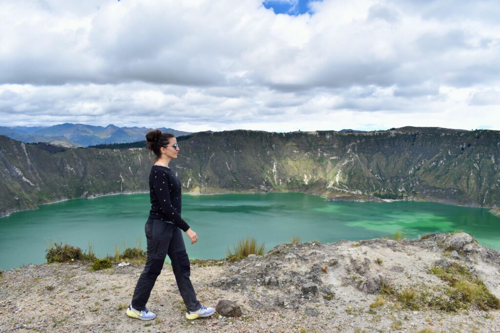
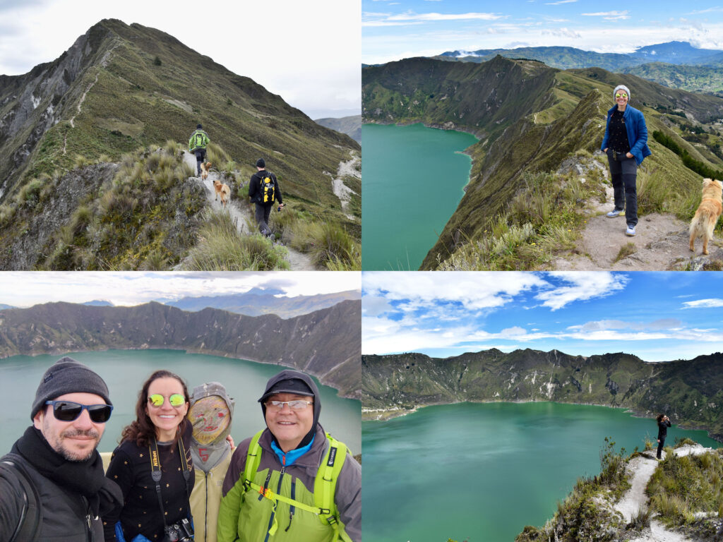
Quilotoa Lagoon
With Edward, we organized ourselves to do the excursions on weekdays because that way we wouldn’t find many people.
The road to Quilotoa lagoon is full of abandoned dogs, it’s very sad. Dogs stand by the side of the highway waiting for people to throw food at them.
As we entered the national park, Edward said “Welcome to Disneyland.” He explained to us that before there was only one community hotel and that, with the rise of tourism, the area had grown disproportionately and had lost its essence.
We were greeted by a bunch of stray dogs coming to see if we had any food. 4 dogs from that group came with us and I called them Quilotoa, Pichincha, Cotopaxi and Corazón. They accompanied us almost to the end and although we did not bring dog food, we gave them nuts.
The trekking was hard due to the height and sometimes due to the characteristics of the terrain. Luckily it was cloudy almost all the time, because only with the half hour of sun we had, we got burned. In fact, the back of my neck peeled off.
Here we took the most beautiful photos of our stay in Quito.
After the trekking we spent a while with the puppies giving them food and water.
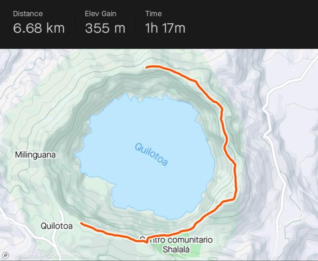
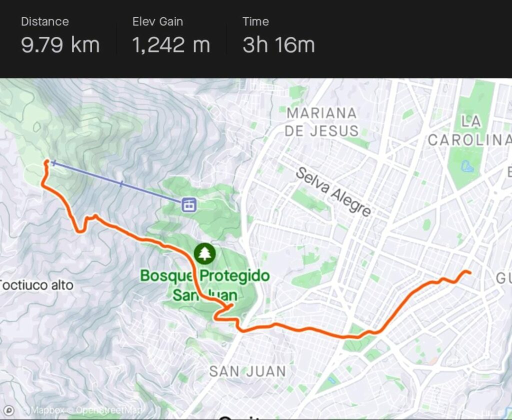
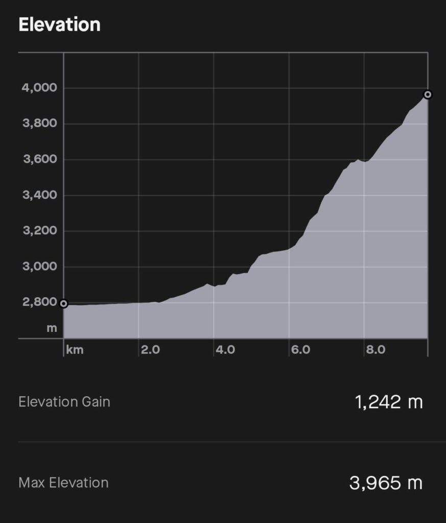
We circled the lagoon completely, but it doesn’t appear on the chart because Diego’s watch went off halfway.
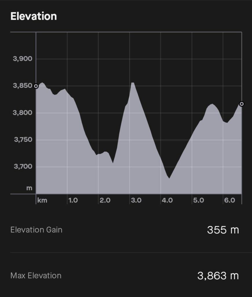
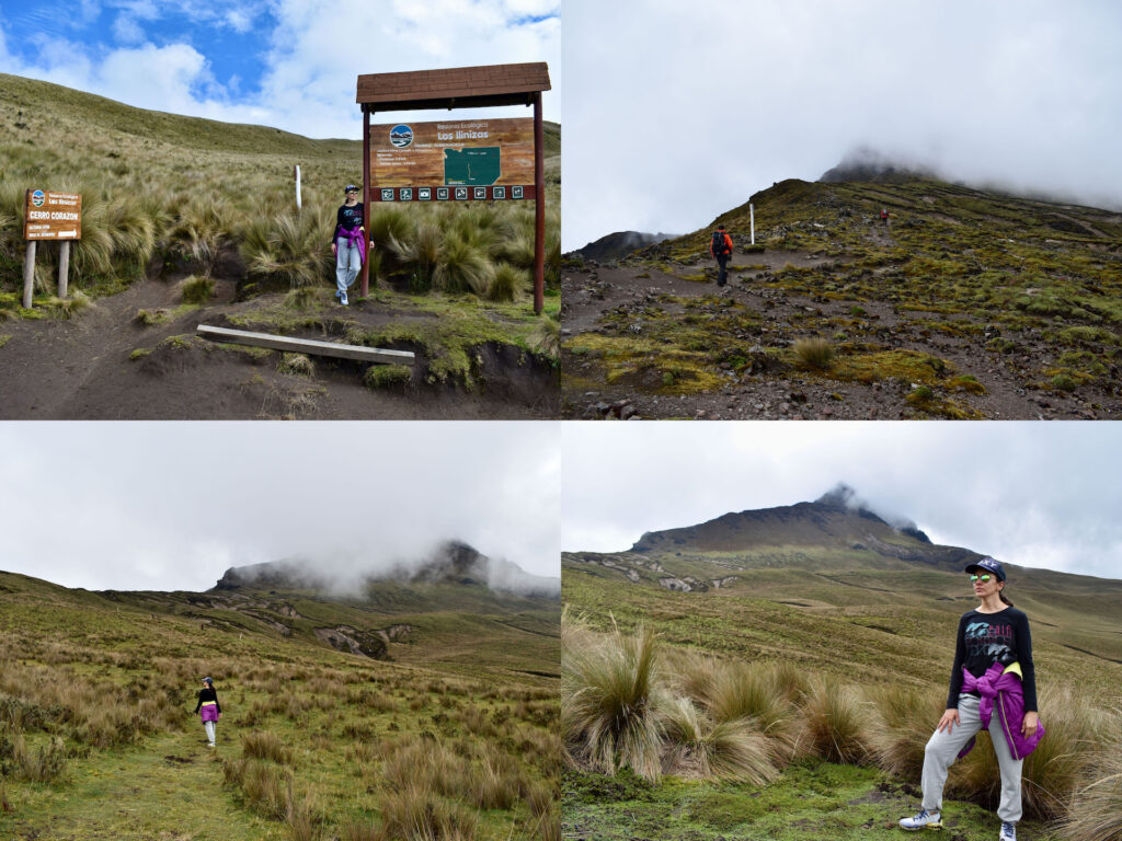
Corazón volcano (Heart volcano)
One Wednesday we went with Edward and his hiking partner Luis to try to summit Corazón volcano. Although they had not yet approved the permit to access the national park due to weather conditions, we decided to give it a try.
Edward told us to bring a change of clothes and I didn’t understand why.
As soon as we got to the parking lot, Edward brought us some forms to fill out and put in the phone number of an emergency contact person. I was a little disconcerted and Edward told me “A lot of people have died here, but don’t worry, nothing is going to happen to us.”
Then I realized that Luis was bringing helmets for everyone, harnesses, ropes… What was going on?
The first part was pure mud and then the route was decent.
At one point there was a shattered trunk and Edward told us that lightning had struck there and that a lot of lightning always fell on that volcano. We had to put cell phones on airplane mode so they wouldn’t attract lightning.
We met a couple who were going down and they told us that they had not reached the summit due to bad weather.
We reached a part where we were about 700 meters away from reaching the summit. Even if you think that 700 meters is not much, at that altitude and with those conditions, that short distance costs you a lot.
From that point on, only black rock could be seen with quite an inclination. We started to put on all the equipment, and it just started to rain and hail, so we couldn’t continue.
Going down the area that was covered by mud was very hard for me (although I was the only one who didn’t fall). I was so tense not to fall that later my neck and head hurt.
When we got to the car the sun came out, although the summit of the volcano was still completely covered by mist. We arrived soaking wet which is why we needed a change of clothes.
I spent some time playing and taking pictures with the puppies. After having been in the Quilotoa Lagoon, I was always prepared with dog food.
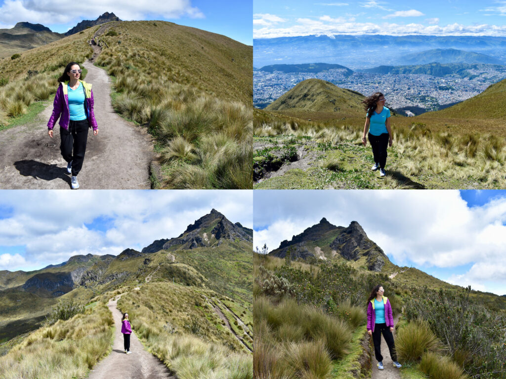
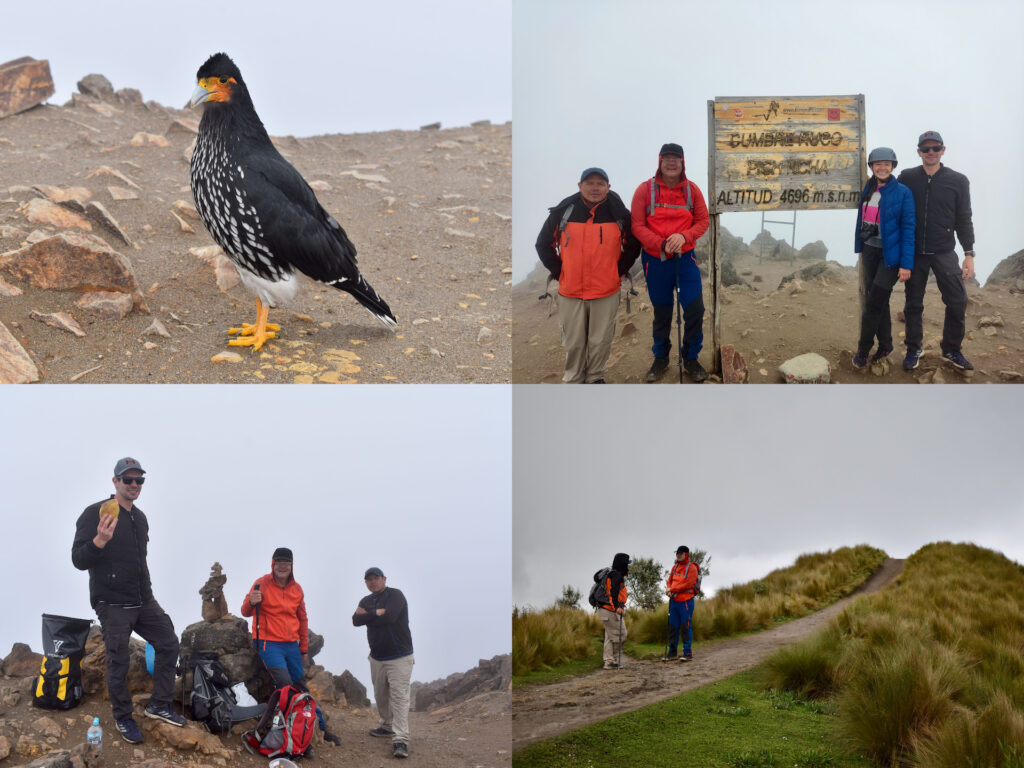
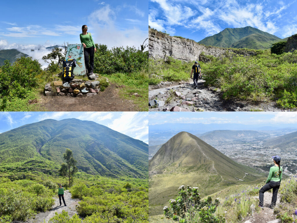
Pichincha volcano
We went 3 times:
- First attempt to reach the summit
- Almost vertical hike through the forest of Miraflores
- Ruco Pichincha Summit
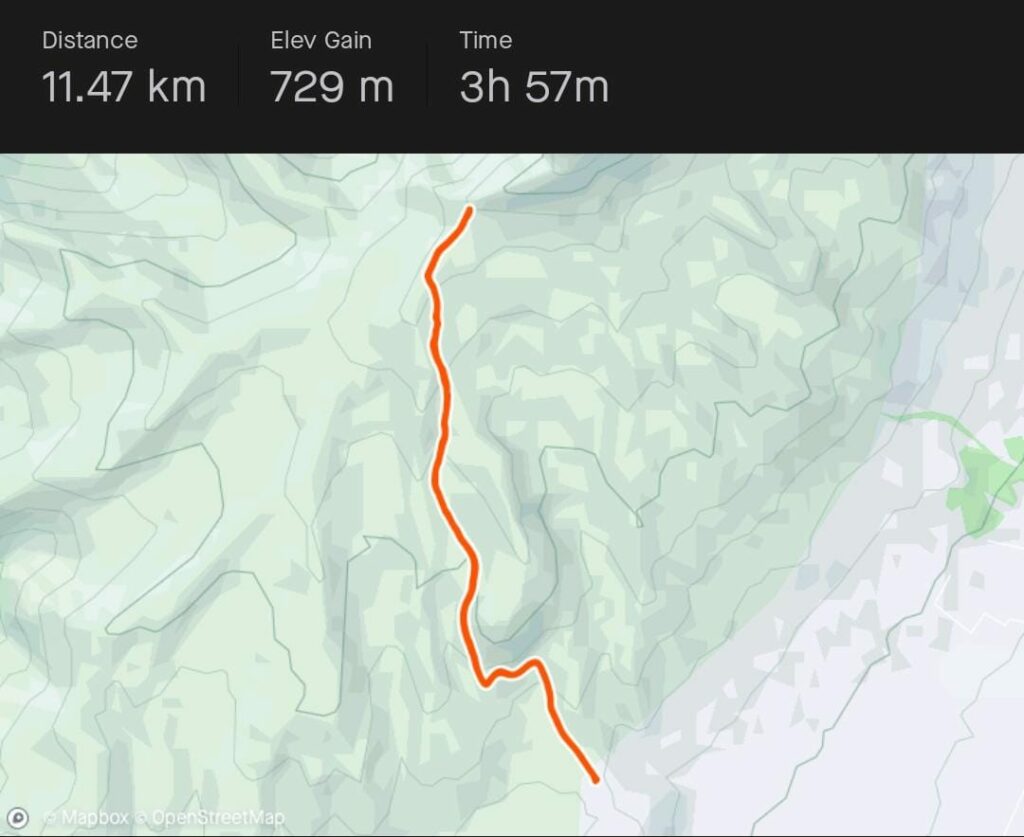
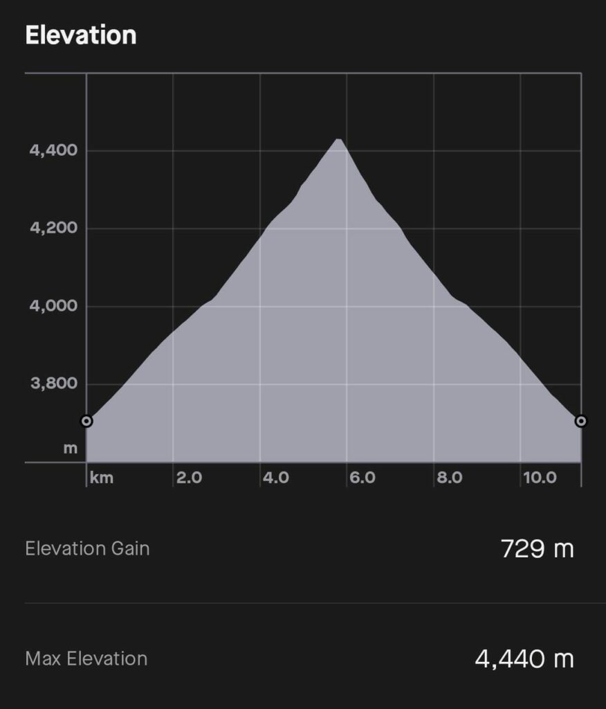
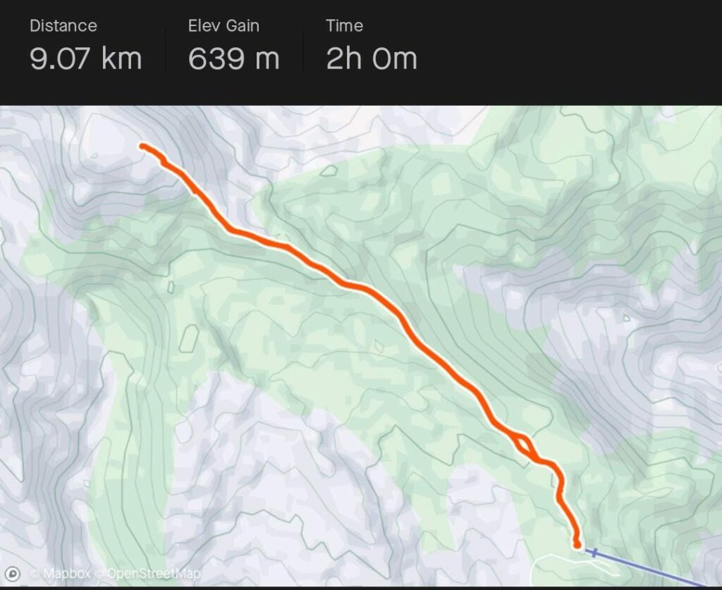
Edward told us that if we went up with the cable car, we could reach the summit of Ruco Pichincha. So, we arrived to be there at the time they opened since it was Sunday and a holiday.
The place is beautiful with incredible views of Quito. Something like that was what we expected in Bogotá.
There were quite a few people, but it was not unpleasant since Ecuadorians are very polite.
The route was not too complicated until we reached a kind of stone wall where we had to climb and there was not even a rope to hold on to. Diego was passing without problems, but halfway through I was blocked by vertigo. We went back, I tried a second time, and I couldn’t either, the fear was stronger than me.
In addition, there were many people with their dogs constantly passing by and that made me even more nervous.
From that point, there were supposedly 50 minutes left to reach the summit.
One Sunday we went to do another route. Just that day I had my period, so I was weak and had cramps. Walking from the house to the beginning of the route was already 50 minutes.
As soon as Diego saw me starting hiking, he asked me if I felt bad because I was slow.
The route started well but it soon became vertical, and it was like that until we reached the cable car. I don’t even know how I got there because I was dying of fatigue all the way. The only flat part was about 100 meters of swamp. Nor was it an option to go back because that way down was very dangerous, and it would be worse to go down than to go up.
Diego was thinking of walking down another route, but we went down by cable car because I couldn’t take it anymore.
Then Luis told us that this route is very good preparation training for the Cotopaxi summit.
The following Wednesday we returned to Pichincha with the intention of reaching the summit and I had already told Edward that I had not been able to continue due to vertigo, his response was “Don’t worry, we’ll see how we do it, we can also go through the death pass”. That answer did not make me calmer.
We met up with Edward and Luis and we went up by cable car. It had rained a lot the day before and it was not possible to climb from where the route begins.
In the queue for the cable car Edward was already telling how to position ourselves in case lightning started to strike. If you did the correct posture “you would get roasted, but you wouldn’t die“.
I don’t know why we all started hiking so fast, as if we were in a hurry. As we had already been there and taken the photos, there was no pause.
We reached the stone wall, Edward got down to grab me in case I slipped, and Luis got ahead to guide me and most importantly, giving me encouragement and confidence to keep going.
I was able to pass that and two more stone walls, which was followed by congratulations and encouragement from the guys. Edward told me that “I was a monster, but I was his idol.”
I soon realized that this wall was the easiest compared to what was left. We continued along the part called the sandbank, which was an almost vertical climb through sand and loose stones. Luis seemed to fly, and we were doing our best to keep up with him and at one point Edward yelled, “Let me breathe!”
Luis put a helmet on me because it was time to climb rocks and the fog helped us not to see that we were climbing on the edge of the precipice.
And we reached the top! I was between happiness and shock that I couldn’t believe it and the first thing I did was hug the sign that indicated that we were at the summit. Then came the hugs and congratulations between us.
Diego and I realized that, even passing the stone wall that blocked me, we would not have reached the summit alone. So, it was thanks to the help and patience of Edward and Luis that we were able to get there.
We ate some vegan empanadas, nuts, took photos, gave food to the Curiquingues, and started our way back.
The descent was worse than the ascent and I went almost all the way on all fours like a crab. All the way down the sand, Luis took me by the hand, telling me to be calm, that he wasn’t going to let anything happen to me.
As we passed the stone walls on our way back, I felt 10 kilos of tension lift from me.
Although we were already going through the easy part, hail started to fall right away and luckily, I hadn’t taken off my helmet yet. We got to the cable car soaking wet. During the descent, Edward told me that it was better to be afraid so as not to trust oneself, because many people had died in Ruco Pichincha.
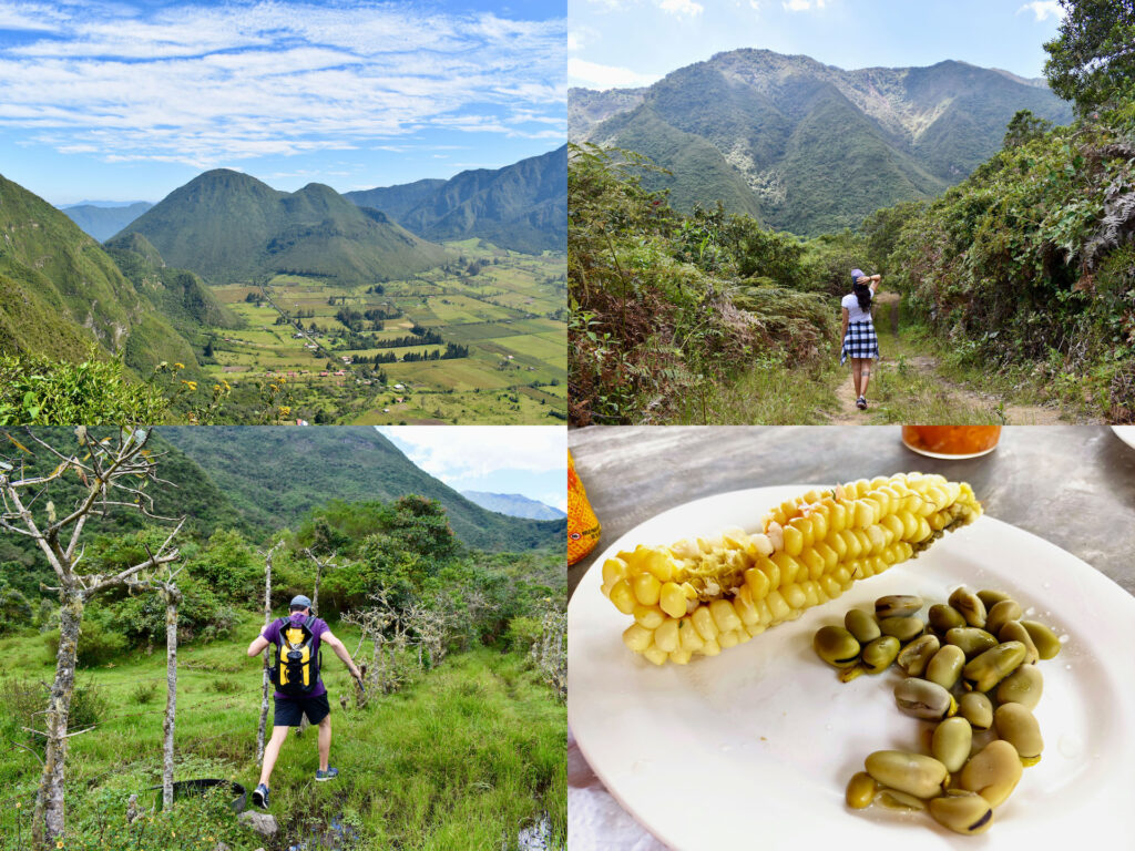
Pululahua and Half of the World
We took an Uber to the entrance of the national park. From our accommodation it was about an hour.
You do not have to pay entry, but they take your data for security.
The route was around the Pondoña dome in the Pululahua crater and was relatively easy. The only difficult thing was the end of 2km of climb.
In parts of this trek, I felt like in the Gran Sabana of Venezuela.
Before beginning the ascent to the end, we found a house where they sold, among other things, corn with cheese for $1; Since we are vegans, they gave us beans instead of cheese. After that delicacy, the climb felt easy.
We walked down the road and found a stand where they sold cold coconuts, where we took the opportunity to cool off.
That day felt very perfect: pleasant trekking, corn, cold coconut…
We continue to the Middle of the World and decided not to enter. I had been in 2011 and it seemed like Disneyland; Apart from the line that marks the middle of the world, the rest are souvenir shops.
Soon hail began to fall, and we got into the Uber soaking wet. The way back was tense since at one point everything was flooded and the hail fell heavily.
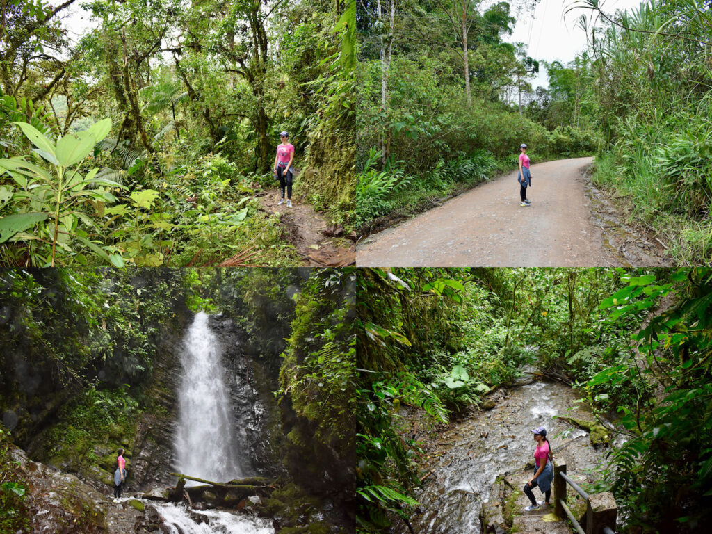
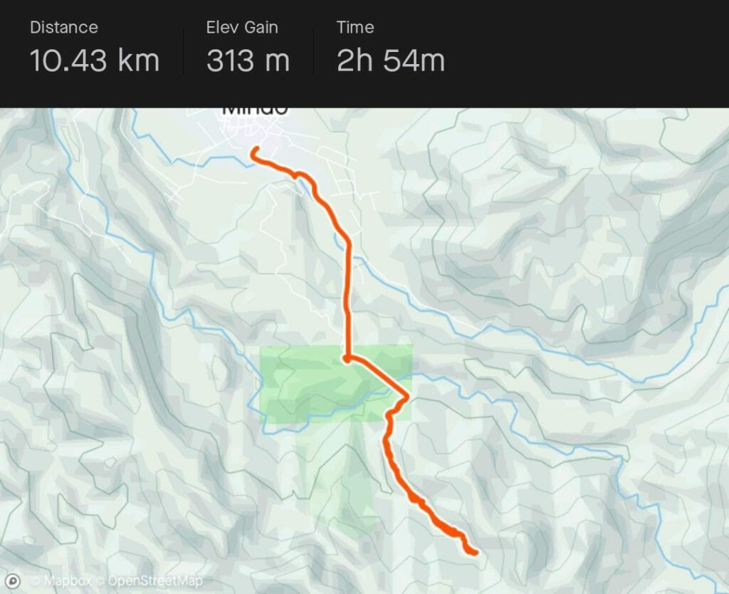
Mindo
Mindo is one of the places that everyone recommends, but I don’t.
We went by bus, which takes 2 hours and costs around $8 round trip.
The area is very rural and full of restaurants. We went to look for the chairlifts that led to where the trek began to see the waterfalls.
Chairlifts are $8 per person for a 15-minute ride.
They did not explain anything to us, and it turned out that upstairs we had to pay again.
There was a station with a cable car, and they told us that it cost $5 per person for a journey of less than 5 minutes.
As it seemed like another robbery, we decided to walk and one of the employees came running after us to tell us that, even if we walked, we still had to pay since the mountain was “private property”.
We later found out that it wasn’t private property, but that some guy had appropriated the mountain and monopolized its use. It is worth highlighting the damage that this management has caused to the ecosystem.
We went directly to see the largest waterfall and I didn’t think it was anything special, a waterfall like so many I saw when I was hiking in El Ávila in Caracas. In addition, after seeing truly incredible waterfalls such as Angel Falls or Iguazú Falls, the ones from Mindo seemed insignificant.
Mindo is a beautiful place, but the management and the supposed “privatization” carried out by the criminals who have appropriated the mountain, makes it not worth going.
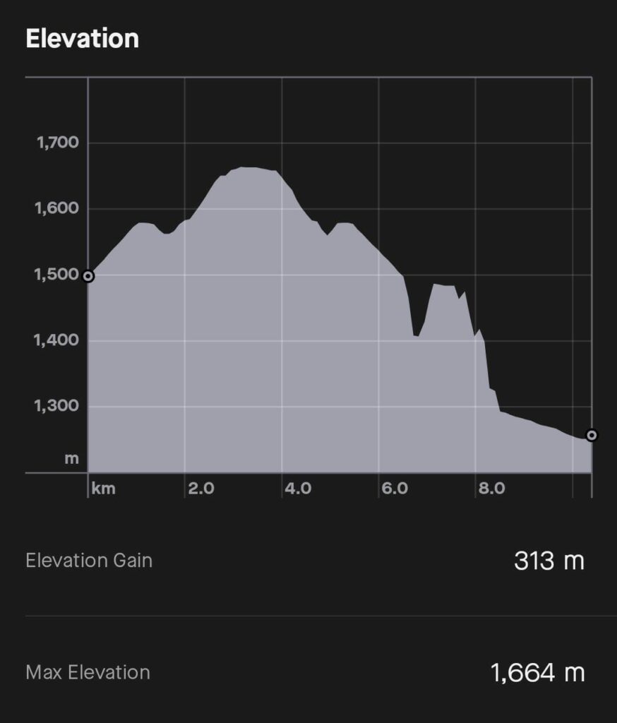
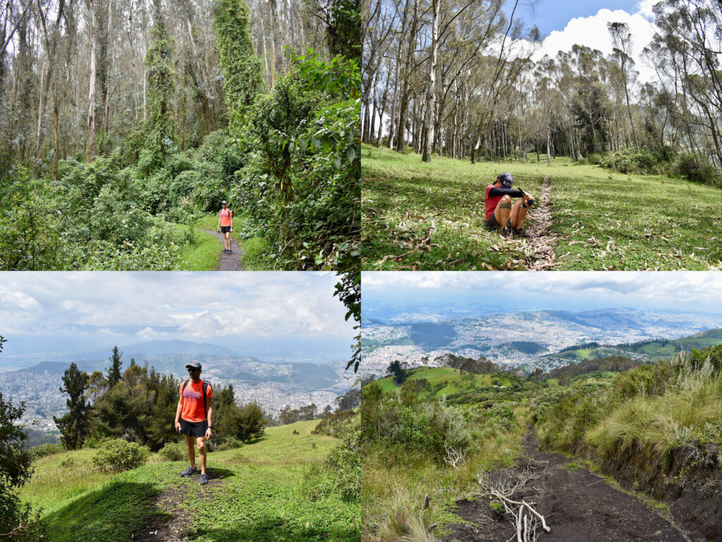
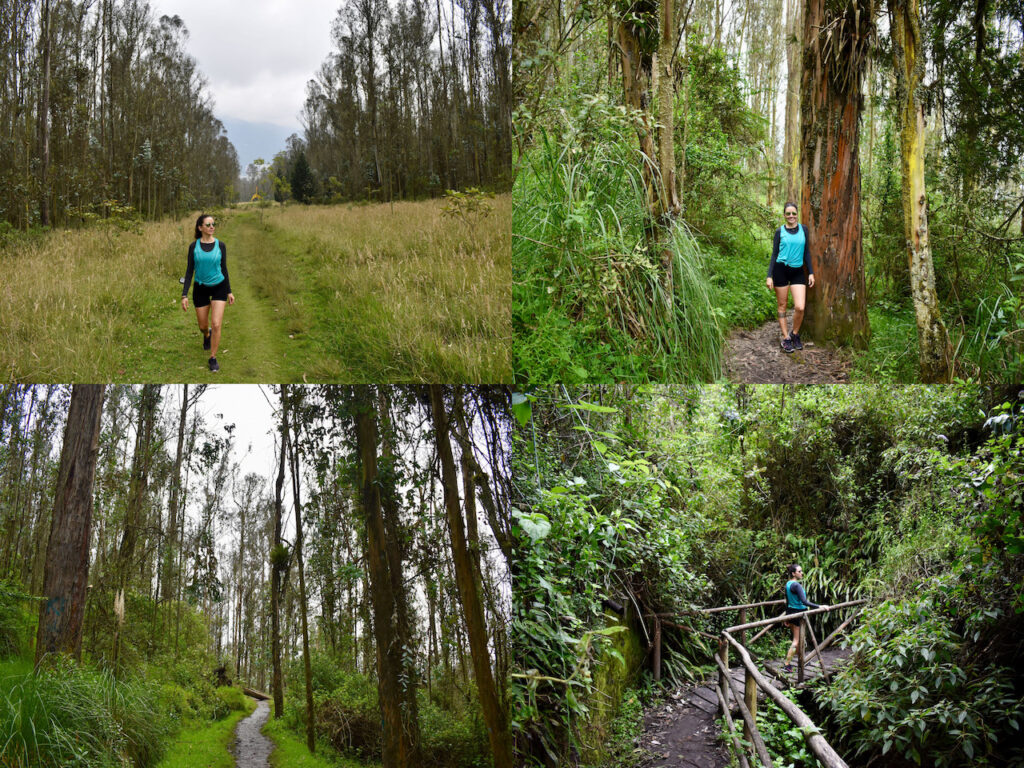
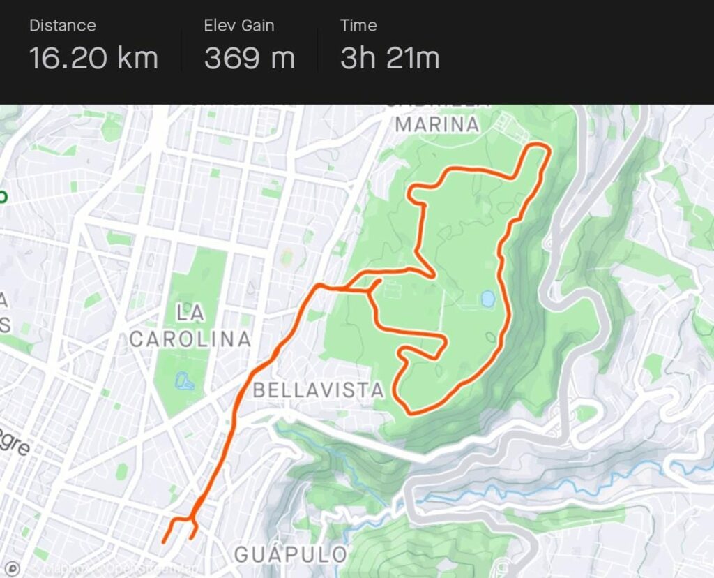
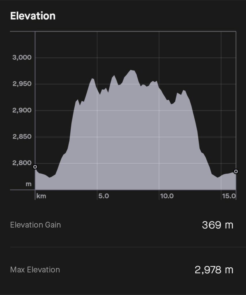
Guanguiltagua Metropolitan Park
We had this park 40 minutes walking from our accommodation, and it looks more like a forest.
Although for people who climb mountains this park is worth nothing, we would have dreamed of having a place like this in Playa del Carmen, Colombia and Peru.
Here we did a relatively easy 10km trek.
Sincholagua Mountain
This was our last hike and Edward suggested it to us since he couldn’t accompany us that weekend.
The idea was to do a mini-integrated of Sincholagua and La Marca mountains
The climb was almost vertical, and I did almost all of it on all fours. Also, ever since we started walking, we were plagued by giant flies that bit through our clothes. Of those that bite cattle.
That was the only day we had sunburst the entire time, which is not good because in Ecuador the sun is very strong.
So, I was already quite overwhelmed during the climb. The last part was complicated and even worse to get down because I felt like I was going to fall off the cliff.
The descent was desperate, and I fell twice. As far as the flies and the heat, now I had to add the pain of the falls. Although the most unbearable were the flies that did not stop hanging around and biting us.
I was so fed up that at times I stood up and screamed in despair.
Since everything from the falls already hurt, we decided not to climb La Marca because the route looked worse. Also, since we were holding on to the branches because we were almost skidding, we also ended up with our hands full of small cuts.
Here are the links to my YouTube channel:
More articles about my trip to Ecuador: